
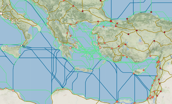
A New Map of Paul’s Missionary Journeys
imageTitle
Paul’s Missionary Journeys
imageCaption
Click to view interactive version.
date
Jul 5, 2018
description
A new map of Paul's Missionary Journeys upgrades from print-based paradigms with an interactive interface overlaid on the roads, provinces, and cities of…
publish
publish
imageLink
When I look at the maps in the back of my Bible, I want to know what passages tell the story of those places. With maps on my phone, I can zoom in closer and tap to get all the information I need. Why can’t we do that with biblical maps? Why must we flip back and forth between pages or app windows? Why weed through search results that may refer to a different place with the same name?
A new map of Paul’s missionary journeys is a big upgrade from the print-based paradigm, giving you more details on demand and control over which routes are visible. The background starts with ancient Roman provinces, then reveals roads and cities as you zoom in. All of it is built with advanced tools from Mapbox for a smooth experience on any screen.
How it Works
Each journey is colored according to the legend at the top. Arrows show the direction of travel and stars point out the start and end of each trip. Sections with arrows pointing both directions indicate where Paul retraced his steps on the return trip.
Clicking the name of a journey will show only that route and the stops along the way. Clicking on a stop shows a pop-up with links to Bible references and more details in the Digital Atlas of the Roman Empire (DARE), the main source for the data behind this map.
The Roman World
The detail in DARE allows us to draw the likely paths that Paul and his companions may have taken on Roman roads. While we cannot be certain about the exact paths they chose, adding this information shows the reader they went along a well-developed transportation network, not a meandering route over rough terrain. Without these roads, Paul could not have gone as far or as fast when taking the Gospel to Judea, Samaria, and the ends of the earth.

In ancient times, rivers were as important as roads for transportation. Over the centuries, people have altered the course of natural waterways. To show the shape of rivers and lakes as they were long ago, this map uses files from the Ancient World Mapping Center at the University of North Carolina at Chapel Hill.
Educated Guesses
Each line for a given journey shows only one possible route, but there were other options to get from point to point. Choosing whether to draw a line on this road versus that road (or a river) is sometimes based on limited evidence. We don’t have the benefit of a written travel log between places listed in the book of Acts, so I have leaned on other research.
Besides Bible atlases, two papers by Mark Wilson, Director of the Asia Minor Research Center, were especially useful. The first covers the possible routes between Perga and Pisidian Antioch on the first journey. The second gets into how Paul might have crossed Asia Minor between Iconium and Troas while being “forbidden by the Holy Spirit to speak the word in Asia” (Acts 16:6).
Water routes are especially difficult since we lack information on shipping lanes. For that, we turn to ORBIS: The Stanford Geospatial Network Model of the Roman World. It builds sea routes using a model based primarily on wind speed and direction data, combined with available historical evidence. ORBIS shows sharper turns in the sea than the smooth curves between ports shown in Bible atlases, which makes sense when comparing those to modern nautical data from shipmap.org.
The Next Journey
This map of Paul’s journeys is only the first step in closing the gap between static images and what we expect from today’s rich user experiences. Wouldn’t it be great to link these stories to a timeline or show who was with him on those long, weary roads? What if we could click a place and see every major event that happened there, who else has visited, or if the name of it had changed?
To answer those questions, we need more data and more ways to communicate the connections between subjects in scripture. I am developing a plan to make that happen. Read about the vision and keep an eye on this blog for more details as progress unfolds.